Enriching Traffic Information with a Spatiotemporal Model Based on Social Media
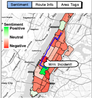
In this work, we argue that Location-Based Social Media (LBSM) feeds may offer a new layer to improve traffic and transit comprehension. Initially, we showed the significant correlation between Twitter’s feed and traditional traffic sensors. Then, we presented the Twitter MAPS (T-MAPS) a low-cost spatiotemporal model to improve the description of traffic conditions through tweets. T-MAPS enhance traditional traffic sensors by carrying the human lens into the transportation system. We conducted a case study by running T-MAPS and Google Maps route recommendation, in which, we showed T-MAPS viability, as an additional traffic descriptor. As a result, we noticed the median of route similarity reached 62%, and for a quarter of the evaluated trajectories, the similarity achieved between 75% and 100%. Also, we presented three route description services, based on natural language analyzes, Route Sentiment (RS), Route Information (RI), and Area’ Tags (AT) aiming to enhance the route information.
Please cite:
@inproceedings{santos2018enriching,
  title={Enriching traffic information with a spatiotemporal model based on social media},
  author={Santos, Bruno P and Rettore, Paulo HL and Ramos, Heitor S and Vieira, Luiz FM and Loureiro, Antonio AF},
  booktitle={2018 IEEE Symposium on computers and communications (ISCC)},
  pages={00464--00469},
  year={2018},
  organization={IEEE}
}
Bruno P. Santos, Paulo H. L. Rettore, Heitor S. Ramos, Luiz F. M. Vieira, and Antonio A.F. Loureiro.
Contatcs: {bruno.ps, rettore, lfvieira, loureiro}@dcc.ufmg.br heitor@ic.ufal.br
Founding agencies: CNPq/CAPES/FAPEMIG.
Leave a comment